Showing 31 items matching stoney creek
-
 Clunes Museum
PRINTING PLATE, Stoney Creek School, map of Australia made by students with stones
... Stoney Creek School, map of Australia made by students with...stoney creek...METAL PRINTING PLATE WITH IMAGE OF THE SITE OF STONEY CREEK... PLATE Stoney Creek School, map of Australia made by students ...METAL PRINTING PLATE WITH IMAGE OF THE SITE OF STONEY CREEK SCHOOLlocal history, documents, newpaper, publishing, schools, stoney creek -
 Clunes Museum
Photograph
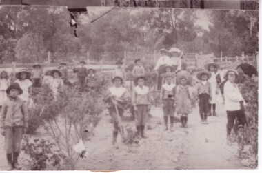
... stoney creek... MISS JAMES TAUGHT AT CLUNES TILL 1930'S IN THE STONEY CREEK....1 BLACK AND WHITE PHOTOGRAPH SCHOOL STUDENTS AT STONEY... STUDENTS AT STONEY CREEK SCHOOL IN THEIR GARDEN WITH TWO ADULTS ...MISS JAMES , A FORMER CLUNES RESIDENT TAUGHT AT STONEY CREEK SCHOOL 1906 - 1912. THE SCHOOL NESTLED IN THE BUSHLAND MISS JAMES TAUGHT AT CLUNES TILL 1930'S IN THE STONEY CREEK SCHOOL YARD, MISS JAMES AND STUDENTS LAID ROCKS IN THE SHAPE OF AUSTRALIA WHICH PROBABLY STILL REMAINS..1 BLACK AND WHITE PHOTOGRAPH SCHOOL STUDENTS AT STONEY CREEK SCHOOL IN THEIR GARDEN WITH TWO ADULTS IN BACKGROUND SCHOOL CLOSED IN 1916 .2 Envelope with provenance of the Stoney Creek School provided with the donation of the photographSAT PAPER ON REVERSE SIDElocal history, photography, photographs, schools, stoney creek -
 Halls Gap & Grampians Historical Society
Photograph - B/W, C 1887
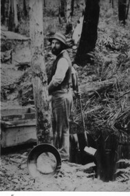
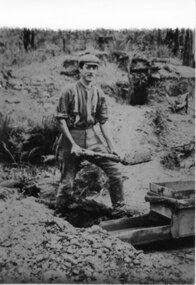
... Stoney Creek...Photo of Charles D'Alton looking for gold on Stoney Creek. ... Photo of Charles D'Alton looking for gold on Stoney Creek ...This is an extract/copy of an original photo that showed both Alfred and Charlie D'Alton together. (see Record # 127 for section with Alfred D'Alton and Record # 117 for the entire photo).Photo of Charles D'Alton looking for gold on Stoney Creek. people, d'alton, mining, stoney creek -
 Halls Gap & Grampians Historical Society
Photograph - B/W, C 1887
... Stoney Creek...Photo of Alfred D'Alton looking for gold on Stoney Creek.... Photo of Alfred D'Alton looking for gold on Stoney Creek ...This is an extract/copy of an original photo that showed both Alfred and Charlie D'Alton together. (see Record # 126 for section with Charles D'Alton and Record # 117 for the entire photo).Photo of Alfred D'Alton looking for gold on Stoney Creek.people, d'alton, mining, stoney creek -
 Halls Gap & Grampians Historical Society
Photograph - B/W
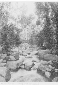
... Stoney Creek...The creek is Stoney Creek... Stawell Stony Creek (sic) Grampians The creek is Stoney Creek ...The creek is Stoney CreekPhoto shows man sitting on rock in middle of creekPicard Stawell Stony Creek (sic) Grampians scenery, stoney creek -
 Halls Gap & Grampians Historical Society
Photograph - Sepia
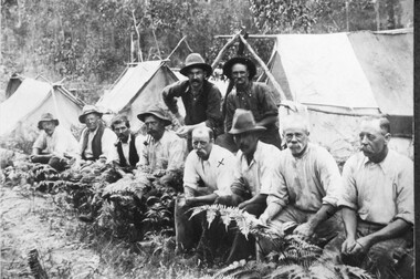
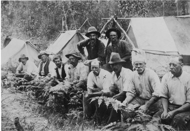
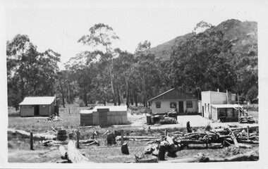
... Grampians Halls Gap & Stoney Creek dredge. circa 1909...Grampians Hallls Gap & Stoney Creek dredge circa 1909... in background. Grampians Hallls Gap & Stoney Creek dredge circa 1909 ...Grampians Halls Gap & Stoney Creek dredge. circa 1909 . 2nd man from right is Alfred D'/alton; 4th from right is James OliverPhoto shows eight men seated, two standing. 3 tents in background.Grampians Hallls Gap & Stoney Creek dredge circa 1909 written on backpeople, d'alton, water supplies, channels -
 Halls Gap & Grampians Historical Society
Photograph - Sepia, C 1920s
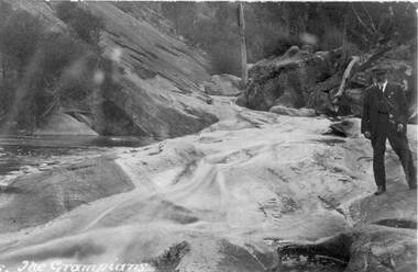
... Stoney Creek... "The Grampians " is written bottom left. The creek is Stoney creek/site... is Stoney creek/site Venus Baths. SCENERY Stoney Creek ...Photo is probably a copy of a postcard. A caption "The Grampians " is written bottom left. The creek is Stoney creek/site Venus Baths.Photo shows man standing by a swiftly flowing creek. He is standing on a rocky platform. Slabs of rock can be seen in background. The man is wearing a cap with suit and tie.Quality paper made in Germanyscenery, stoney creek -
 Halls Gap & Grampians Historical Society
Photograph - B/W, C 1887
... Stoney Creek... to at Stoney Creek diggings Left to Right Jim, John and Charles D/Alton... PEOPLE D'Alton MINING Stoney Creek ...Afred D'Alton was the first to discover alluvial good in Stony CreekPhoto shows members of D/Alton family outside lean to at Stoney Creek diggings Left to Right Jim, John and Charles D/Alton, Henrietta and Amy (John's daughters) Galbraith (John's son) Clare (Charlie and Jim's sister)Larger photo taken from original people, d'alton, mining, stoney creek -
Stawell Historical Society Inc
Photograph, "To Know Him Was To Love Him." --- Colour Photo of the Watercolour painting by Mr Will J Rees
... Stoney Creek... Mountains, Victoria; looking east from Stoney Creek. Painted 1905... from Stoney Creek. Painted 1905. From the estate of Mrs Jean ...Photo of Will Rees Watercolour (1905) Looking East from Stoney CreekColour photo of reduced water colour. Halls Gap, Grampians Mountains, Victoria; looking east from Stoney Creek. Painted 1905. From the estate of Mrs Jean Hughes.stawell -
 Halls Gap & Grampians Historical Society
Photograph - B/W, C 1940- (before 1950)
... Stoney creek has been 'bridged' a number of times in School...Photo of 'school bridge' over Stoney Creek. Gravel road... Photo of 'school bridge' over Stoney Creek. Gravel road ...Stoney creek has been 'bridged' a number of times in School Rd, since the creek was re-routed in the early 1900's. A dray bridge was built c1910 by local residents which stood them in good stead for more than a decade.Photo of 'school bridge' over Stoney Creek. Gravel road in foreground leading to a wooden bridge surrounded by tall gum trees.structures, bridges -
 Halls Gap & Grampians Historical Society
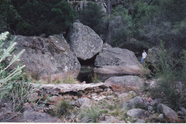
Photograph - Coloured, 24/04/2005
... Stoney Creek...The photo shows a small weir on the Stoney Creek which used... to the weir. The photo shows a small weir on the Stoney Creek which ...The photo shows a small weir on the Stoney Creek which used to supply water to a number of early businesses in Halls Gap, such as the general store and Grampians House. Each business ran a pipe from the weir to their premises and three outlets can still be seen embedded in the wall. Record 248 was taken at the same time.Photograph of a woman approaching a small weir with three large boulders behind it. The original level of the weir can be seen on the boulders. The additional image is a description of how to get to the weir.scenery, stoney creek -
 Halls Gap & Grampians Historical Society
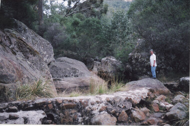
Photograph - Coloured, 24/04/2005
... Stoney Creek...The photo shows a small weir on the Stoney Creek which used... to the weir. SCENERY Stoney Creek ...The photo shows a small weir on the Stoney Creek which used to supply water to a number of early businesses in Halls Gap. The weir's former level can be seen on the large rocks behind but once a town water supply was installed, the wall of the weir was breached. Record 247 was taken at the same time and includes an image of a description of how to get to the weir.Photograph of a woman approaching standingh on a rock near a small weir. There are large boulders behind it which show the former level of the weir.scenery, stoney creek -
 Halls Gap & Grampians Historical Society
Photograph - B/W, C 1902
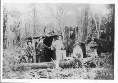
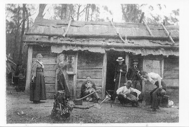
... The dwelling is said to be the store at the Stoney Creek..."Store at Stoney Creek diggings ?1902. Alice Maria Langley... with the contents of the pan. "Store at Stoney Creek diggings ?1902. Alice ...The dwelling is said to be the store at the Stoney Creek diggings, with some members of the Langley family. From left Alice Maria Langley, Lucy, ?, ?, Charles Langley (old man) & three friends.Photo shows three women and three men standing and sitting outside a slab hut. The roof of the hut appears to be constructed of bark, held in place by saplings. One of the men is sitting against the side of the hut and is holding a dog. Another man is crouched over a gold pan while an onlooker appears happy with the contents of the pan."Store at Stoney Creek diggings ?1902. Alice Maria Langley, Lucy ? ? Charles Langley (old man) & three friends." written on back in blue pen.people, langley, mining, gold mining -
 Orbost & District Historical Society
black and white photograph, 1977?
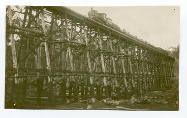
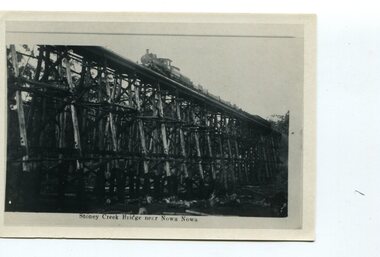
... Stoney-Creek trestle-bridge railway East-Gippsland-railway... this bridge, the highest trestle bridge in Victoria at Stoney Creek... in Victoria at Stoney Creek. The Stony Creek Trestle Bridge was built ...In 1977 great efforts were being made to preserve this bridge, the highest trestle bridge in Victoria at Stoney Creek. The Stony Creek Trestle Bridge was built in 1916 when the existing rail line from Melbourne to Bairnsdale was extended to Orbost. This 97km Bairnsdale to Orbost extension through rugged terrain was reputed to have been the most difficult rail project undertaken in Victoria. In service for over 60 years the bridge was damaged by bushfire in 1980, with the last train crossing in 1987. At 247m long and 20m high, it is the largest standing bridge of its kind in the State, and is listed on the Register of Historic Sites. Built of red ironbark and grey box timber, it is a fine example of the early engineering skills that utilised the resources and materials found on site.The Bairnsdale to Orbost rail line contains the most varied range of timber & timber composite bridges on any Victorian line. The Stoney Creek bridge is listed on the Victorian Heritage Register for its architectural and historical significance.A black / white photograph of a very large trestle bridge. a steam locomotive, with loaded goods trucks, is on the bridge. stoney-creek trestle-bridge railway east-gippsland-railway -
 Halls Gap & Grampians Historical Society
Photograph - B/W, C 1898
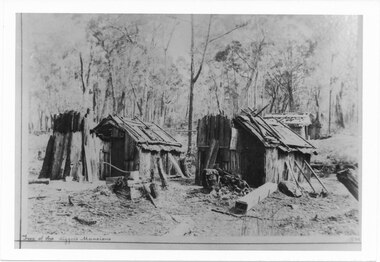
... Stoney Creek... written on front BUILDINGS Houses Stoney Creek ...Photo depicts 2 slab huts in foreground and 2 in back right corner Site of Sony Creek DigginsTwo of the diggers mansions written on frontbuildings, houses, stoney creek -
 Halls Gap & Grampians Historical Society
Photograph - B/W, C 1887
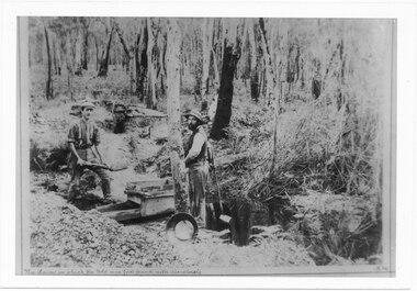
... Stoney Creek... man separately. PEOPLE D'Alton MINING Stoney Creek ...D'Alton's searching for alluvial gold. Photo shows Alfred and Charles D'Alton at Stony Creek Diggings. Charles is on the right and Alfred is on the left. Records 126 and 127 are enlargements from this photo showing each man separately.Photo shows two men working near a sluice. One man is shovelling into a sluice, on a creek and the other is holding an implement. A gold pan rests against a tree.people, d'alton, mining, stoney creek -
 Halls Gap & Grampians Historical Society
Photograph - B/W, C 1887
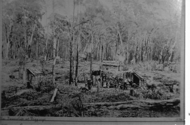
... Stoney Creek.... the township at Diggings marked on front MINING Stoney Creek ...Photo depicts dwellings with people standing in front. A man is holding a horse loaded with bags. Huts in forground and background.the township at Diggings marked on frontmining, stoney creek -
 Halls Gap & Grampians Historical Society
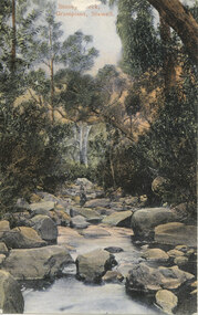
Postcard - Coloured, C 1906
... Stoney Creek... as Rec601b. SCENERY Stoney Creek ...Postcard has been addressed to Miss E. Westmoreland Child St. Stawell, with the message "Many Happy Returns from Jurgums? The coloured postcard was printed in Germany. Date of message 13.10.06. Scan of rear saved as Rec601b.Postcard shows a man sitting on a rock in the middle of a creek. There are many big boulders and bush on both sides. A gum tree with a white trunk stands in the middle foreground.scenery, stoney creek -
 Orbost & District Historical Society
black and white photograph, first half 20th century
... railway-bridge stoney-creek-bridge east-gippsland-railway... composite bridges on any Victorian line. The Stoney Creek bridge ...The Stony Creek Trestle Bridge was built in 1916 when the existing rail line from Melbourne to Bairnsdale was extended to Orbost. This 97km Bairnsdale to Orbost extension through rugged terrain was reputed to have been the most difficult rail project undertaken in Victoria. In service for over 60 years the bridge was damaged by bushfire in 1980, with the last train crossing in 1987. At 247m long and 20m high, it is the largest standing bridge of its kind in the State, and is listed on the Register of Historic Sites. Built of red ironbark and grey box timber, it is a fine example of the early engineering skills that utilised the resources and materials found on site.The Bairnsdale to Orbost rail line contains the most varied range of timber & timber composite bridges on any Victorian line. The Stoney Creek bridge is listed on the Victorian Heritage Register for its architectural and historical significance. A black / white photograph of a very tall wooden railway bridge with a train along the top.railway-bridge stoney-creek-bridge east-gippsland-railway -
Clunes Museum
NEWSPAPER ARTICLE, Feb-85
... STONEY CREEK... SCHOOLS STONEY CREEK ...THE SCHOOL OPERATED BETWEEN 1865 UNTIL 1916. STONY CREEK IS IN THE TALBOT AREA. THE ARTICLE WAS PUBLISHED IN THE BALLARAT NEWS ON 6TH FEBRUARY, 1985NEWSPAPER ARTICLE ABOUT THE FORMER STONY CREEK SCHOOL WRITTEN BY ROS. O'BRIENlocal history, schools, stoney creek -
 Halls Gap & Grampians Historical Society
Photograph - B/W, C ?
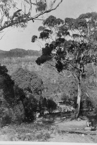
... This is the ford over the Stoney Creek and shelter shed.... the Stoney Creek and shelter shed. ACCESS ROUTES Roads ...This is the ford over the Stoney Creek and shelter shed.The photo shows a track leading down to a large pergola type structure, surrounded by thick bush. There is a tall gum on the right of the picture, beside the track. A large branch of a tree can be seen in the top left foreground.access routes, roads -
 Halls Gap & Grampians Historical Society
Photograph - B/W, C 1920s
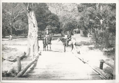
... The Stoney Creek dray bridge. Stoney Creek has been... and there are thick trees surrounding the road. The Stoney Creek dray bridge ...The Stoney Creek dray bridge. Stoney Creek has been bridged a number of times on school road since the creek was re-routed in the early 1900s. A dray bridge was built C 1910 by local residents, which stood them in good stead for more than a decade. This bridge was replaced by a higher timber structure. Image two is a story from 1906 relating to Marshall White and his family trying to recross Delley's bridge after finding the Stoney Creek dray bridge washed away.Photo of two men on horseback on a wooden bridge with low log railing. A shelter can be seen in the background and there are thick trees surrounding the road.structures, bridges -
 Halls Gap & Grampians Historical Society
Photograph - Sepia, C 1909
... Grampians halls Gap at Stoney Creek Dredge. The site... halls Gap at Stoney Creek Dredge. The site of the Stoney Creek ...Grampians halls Gap at Stoney Creek Dredge. The site of the Stoney Creek diggings was in the upper catchment area of the creek, beside Silverband Road. For further information see: 'Bridging the Gap' by Ida Stanton, p. 49 and 'Victoria's Wonderland' by Halls Gap and Grampians Historical Society, p. 41.Photo shows eight men seated, two standing, 3 tents in background. 2nd right Alfred D'Alton 4th Right James Oliverwater supplies, d'alton, water supplies, channels -
 Halls Gap & Grampians Historical Society
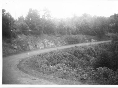
Photograph - B/W, C 1930s-1940s
... Stoney Creek Gorge.... This section of the raod is beyond Stoney Creek Gorge ACCESS ROUTES Mt ...Mt Victory Rd once known as the Bluff road was opened by Lady Somers Mar 1930. This section of the raod is beyond Stoney Creek Gorgephoto shows sweeping bend on Mt Victory Rdaccess routes, mt victory rd, roads -
 Halls Gap & Grampians Historical Society
Postcard - B/W, C 1929
... of the Stoney Creek is in the foreground.... of the Stoney Creek is in the foreground. MEDIA Advertisements PEOPLE ...The back of Warren's/Greer's Bakery on the far right side, with the back of Warrens/Greer's house adjacent (and at right angles to the bakery). The cottage on the left side was rented out. The bed of the Stoney Creek is in the foreground.Postcard shows three buildings with trees and a hill in the background. There are numerous fallen/felled trees and a fence in the foreground. Robert Greer was the baker. He married Ida Warren.media, advertisements, people, warren -
Stawell Historical Society Inc
Map, T.F. McGauran, William Couty of Borong 1891, 1891
... Creek, Stoney Creek. Stawell Water Supply Aquaduct Fkuming..., Bovine Creek, Glasstree Creek, Stoney Creek. Stawell Water Supply ...Stawell Water Supply Reserve. Grampians State Forest. Dairy Creek, Fyans Creek, Barney's Creek, Bovine Creek, Glasstree Creek, Stoney Creek. Stawell Water Supply Aquaduct Fkuming Tunnel.A2 Parish Map of Willam Inculdin Stawell Water Supply Reserve and Creeks. Marked in redPhoto Lithographed at the Department of Lands and Survey Melbourne. By T.F. McGauran 20.07.91 water supply survey -
 Halls Gap & Grampians Historical Society
Postcard - Sepia, C 1920s
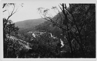
... The road winding up Stoney Creek Gorge with Elephant Hide... winding up Stoney Creek Gorge with Elephant Hide, the rocky slope ...The road winding up Stoney Creek Gorge with Elephant Hide, the rocky slope in the picture, on the left. Sections of the earlier 19th century bridal track, which was later widened to become a jinker track, can be seen above the new road.Postcard shows Mt Victory Rd unsealed Elephant's hide on leftPostcard Correspondence Address only Kodak Mt Vic Roadaccess routes, mt victory rd, roads -
 Halls Gap & Grampians Historical Society
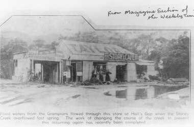
Document - B/W article (magazine/newspaper), C 1930s
... a flood of the Stoney Creek. The creek flowed through the store... Store and Cafe after a flood of the Stoney Creek. The creek ...A photo, that appeared in the magazine section of the Weekly Times in 1937, of Taylor's General Store and Cafe after a flood of the Stoney Creek. The creek flowed through the store at the height of the flood. The course of the creek was changed after this flood to prevent this happening again.A newspaper cutting. It shows a building with three women standing in front of it. The building has TAYLOR painted on the roof and a sign saying "Store & Cafe" there is a large pool of water in the foreground. Trees and hills can be vaguely seen in the background.buildings, shops, natural disasters, floods -
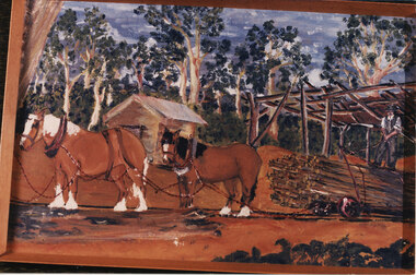 Halls Gap & Grampians Historical Society
Photograph - Coloured, Early 20th C
... on Stoney Creek. The tramline was made of timber and the trolleys... on Stoney Creek. The tramline was made of timber and the trolleys ...A tramline was built to bring logs down from a mill up on Stoney Creek. The tramline was made of timber and the trolleys of logs were pulled as afr as possible by horse and then a driver would ride the logs down to the flat land below pulling a brake when nearing the end. (Close to site of present Primary School).Photo is a copy of Anne Borella (nee Nicholson) depicting the haulage of timber along a tramline. Two horses are pulling a trolley while a driver stands on the load with the wheelbrake ready.transport, horse drawn, structures, tramway -
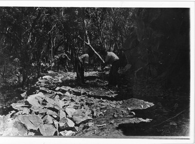 Halls Gap & Grampians Historical Society
Photograph - B/W, C 1920s
... the 1900's access to the Stoney Creek gorge was via a winding.... Until the 1900's access to the Stoney Creek gorge was via ...Men have started to form the Mt Victory Road. Until the 1900's access to the Stoney Creek gorge was via a winding bridal jinker track. Increased traffic lead to much of this route being widened into what became known as Bluff Road. Within a few years the route was further improved and was officially named Mount Victory Road in 1930.Photo shows 3 men working with pick and shovel on roadPick and shovel Mt Victory Rdaccess routes, roads, access routes, road building